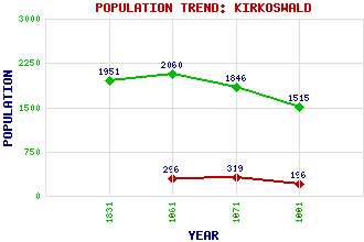
Kirkoswald Classification and Statistics Settlement Type: village Population (1991): 196 (1971): 319 (1961): 296 (1881): 1515 (1871): 1846 (1861): 2060 (1831): 1951 Tourist Rating: Text of Entry Updated: 21-MAR-2003 Location Latitude: 55.33°N Longitude: 4.7744°W National Grid Reference: NS 241 075 A range of modern and historical maps are accessible through the map tab on the right of this page Get directions by entering the UK postcode of your location, home or hotel here eg. EH1 3YT Use the tabs on the right of this page to see other parts of this entry Related Entries There are 13 related entries. (3 Attractions, 1 Council Area, 1 Historical County, 2 Features, 1 Parish, 3 People and 2 Settlements) Names that are not linked do not currently contain any information. Attractions: Souter Johnnie's Cottage Stumpy Tower Thomaston Castle Council Area: South Ayrshire Features: A77 Trunk Road Craigdow Loch Historical Counties: Ayrshire Parishes: Kirkoswald People: Robert Adam Agnes Broun Robert Burns Settlements: Girvan Maybole
There are 13 related entries. (3 Attractions, 1 Council Area, 1 Historical County, 2 Features, 1 Parish, 3 People and 2 Settlements)
Names that are not linked do not currently contain any information.
By using our site you agree to accept cookies, which help us serve you better