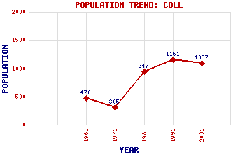
Coll (Col) Classification and Statistics Settlement Type: village Population (2001): 1087 (1991): 1161 (1981): 947 (1971): 305 (1961): 470 Tourist Rating: N/A Text of Entry Updated: 09-MAY-2019 Location Latitude: 58.2744°N Longitude: 6.3251°W National Grid Reference: NB 465 399 A range of modern and historical maps are accessible through the map tab on the right of this page Get directions by entering the UK postcode of your location, home or hotel here eg. EH1 3YT References and Further Reading Grant, James Shaw (1987) Discovering Lewis and Harris. John Donald Publishers Ltd., Edinburgh Use the tabs on the right of this page to see other parts of this entry Related Entries There are 14 related entries. (0 Attractions, 1 Council Area, 1 Historical County, 5 Features, 1 Parish, 1 Person and 5 Settlements) Names that are not linked do not currently contain any information. Council Area: Western Isles Features: Broad Bay Coll, River Lewis Lewis with Harris Outer Hebrides Historical Counties: Ross and Cromarty Parishes: Stornoway People: William Hesketh Lever(1st Viscount Leverhulme of the Western Isles) Settlements: Back Breivig Lighthill Stornoway Upper Coll
There are 14 related entries. (0 Attractions, 1 Council Area, 1 Historical County, 5 Features, 1 Parish, 1 Person and 5 Settlements)
Names that are not linked do not currently contain any information.
By using our site you agree to accept cookies, which help us serve you better