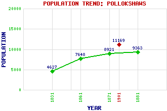
Pollokshaws Classification and Statistics Settlement Type: suburb Population (1901): 11169 (Police Burgh) (1881): 9363 (1871): 8921 (1861): 7648 (1831): 4627 Tourist Rating: Text of Entry Updated: 01-JAN-2009 Location Latitude: 55.8224°N Longitude: 4.3016°W National Grid Reference: NS 559 612 A range of modern and historical maps are accessible through the map tab on the right of this page Get directions by entering the UK postcode of your location, home or hotel here eg. EH1 3YT References and Further Reading Smart, Aileen (1996) Villages of Glasgow: Volume 2 (South of the Clyde). John Donald Publishers Ltd., Edinburgh Use the tabs on the right of this page to see other parts of this entry Related Entries There are 20 related entries. (0 Attractions, 1 Council Area, 1 Historical County, 1 Family, 6 Features, 1 Parish, 6 People and 4 Settlements) Names that are not linked do not currently contain any information. Council Area: Glasgow City Families: Pollock Features: Clyde, River Glasgow South Western Line Pollok Golf Club Pollokshaws East Railway Station Pollokshaws West Railway Station White Cart Water Historical Counties: Renfrewshire Parishes: Eastwood People: Francis (Frankie) Boyle Allan Glen John MacLean James Maxton Robert Angus Smith James Tassie Settlements: Pollok Pollokshields Shawlands Thornliebank
There are 20 related entries. (0 Attractions, 1 Council Area, 1 Historical County, 1 Family, 6 Features, 1 Parish, 6 People and 4 Settlements)
Names that are not linked do not currently contain any information.
By using our site you agree to accept cookies, which help us serve you better