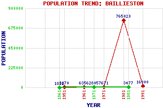
Baillieston Classification and Statistics Settlement Type: suburb Population (1991): 16000 (1981): 765029(Combined with Glasgow) (1971): 7671 (1961): 6356 (1951): 6070 (1881): 3477 (1871): 2805 (1861): 1832 Tourist Rating: No Text of Entry Updated: 18-APR-2007 Location Latitude: 55.8483°N Longitude: 4.1147°W National Grid Reference: NS 677 637 A range of modern and historical maps are accessible through the map tab on the right of this page Get directions by entering the UK postcode of your location, home or hotel here eg. EH1 3YT Use the tabs on the right of this page to see other parts of this entry Related Entries There are 23 related entries. (1 Attraction, 1 Council Area, 1 Historical County, 10 Features, 1 Parish, 4 People and 5 Settlements) Names that are not linked do not currently contain any information. Attractions: Daldowie Doocot Council Area: Glasgow City Features: Baillieston Interchange Baillieston Railway Station Bannerman High School Burntbroom Clyde, River Diocese of Motherwell Garrowhill M74 Motorway Mark Hill Wind Farm Whifflet Line Historical Counties: Lanarkshire Parishes: Old Monkland People: Sir Patrick Dollan Elaine Constance Smith Sir William Johnston Thomson John Wheatley Settlements: Barlanark Barrachnie Easterhouse Glasgow Mount Vernon
There are 23 related entries. (1 Attraction, 1 Council Area, 1 Historical County, 10 Features, 1 Parish, 4 People and 5 Settlements)
Names that are not linked do not currently contain any information.
By using our site you agree to accept cookies, which help us serve you better