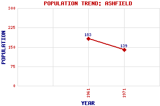
Ashfield Classification and Statistics Settlement Type: hamlet Population (1971): 139 (1961): 183 Tourist Rating: Text of Entry Updated: 27-FEB-2017 Location Latitude: 56.2103°N Longitude: 3.962°W National Grid Reference: NN 784 037 A range of modern and historical maps are accessible through the map tab on the right of this page Get directions by entering the UK postcode of your location, home or hotel here eg. EH1 3YT References and Further Reading Williams, J.D. (1980) Ashfield, a Factory Village in South Perthshire. Forth Naturalist and Historian, Vol. 5 Use the tabs on the right of this page to see other parts of this entry Related Entries There are 11 related entries. (0 Attractions, 1 Council Area, 1 Historical County, 2 Features, 1 Parish, 2 People and 4 Settlements) Names that are not linked do not currently contain any information. Council Area: Stirling Features: Allan Water Glasgow-Perth Line Historical Counties: Perthshire Parishes: Dunblane and Lecropt People: William Ewart Gladstone John Pullar Settlements: Bridge of Allan Dunblane Kinbuck Perth
There are 11 related entries. (0 Attractions, 1 Council Area, 1 Historical County, 2 Features, 1 Parish, 2 People and 4 Settlements)
Names that are not linked do not currently contain any information.
By using our site you agree to accept cookies, which help us serve you better