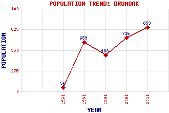
Drumoak Classification and Statistics Settlement Type: N/A Population (2011): 853 (2001): 716 (1991): 483 (1981): 659 (1961): 56 Tourist Rating: N/A Text of Entry Updated: 15-JAN-2001 Location Latitude: 57.077°N Longitude: 2.3562°W National Grid Reference: NO 785 985 A range of modern and historical maps are accessible through the map tab on the right of this page Get directions by entering the UK postcode of your location, home or hotel here eg. EH1 3YT Use the tabs on the right of this page to see other parts of this entry Related Entries There are 8 related entries. (1 Attraction, 1 Council Area, 1 Historical County, 1 Feature, 1 Parish, 1 Person and 2 Settlements) Names that are not linked do not currently contain any information. Attractions: Drum Castle Council Area: Aberdeenshire Features: Dee, River Historical Counties: Aberdeenshire Parishes: Drumoak People: James Gregory Settlements: Kirkton of Durris Peterculter
There are 8 related entries. (1 Attraction, 1 Council Area, 1 Historical County, 1 Feature, 1 Parish, 1 Person and 2 Settlements)
Names that are not linked do not currently contain any information.
By using our site you agree to accept cookies, which help us serve you better