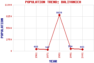
Balivanich (Balivanish, Baile Mhanaich, Bailebhainich) Classification and Statistics Settlement Type: village Population (2001): 443 (1991): 564 (1981): 8639(Combined with Stornoway) (1971): 347 (1961): 488 Tourist Rating: No Text of Entry Updated: 05-JUL-2013 Location Latitude: 57.4727°N Longitude: 7.382°W National Grid Reference: NF 775 552 A range of modern and historical maps are accessible through the map tab on the right of this page Get directions by entering the UK postcode of your location, home or hotel here eg. EH1 3YT Use the tabs on the right of this page to see other parts of this entry Related Entries There are 35 related entries. (2 Attractions, 1 Council Area, 1 Historical County, 18 Features, 1 Parish, 0 People and 12 Settlements) Names that are not linked do not currently contain any information. Attractions: Stones Swim to Islands Taigh Chearsabhagh Museum and Arts Centre Council Area: Western Isles Features: Barra Benbecula Benbecula Airport Benbecula Golf Course Borve Castle Culla East Camp Community Enterprise Park Fada, Loch Hebrides Missile Range Langavat, Loch Liana Moire, Loch na Mor, Loch North Uist Olavat, Loch RAF Benbecula Southern Isles Torcusay, Loch Uist and Barra Hospital Historical Counties: Inverness-shire Parishes: South Uist Settlements: Baymore Creagastrom Daliburgh Gramisdale Griminish Hacklett Liniclate Lochmaddy Nunton Stornoway Uachdar Uskavagh
There are 35 related entries. (2 Attractions, 1 Council Area, 1 Historical County, 18 Features, 1 Parish, 0 People and 12 Settlements)
Names that are not linked do not currently contain any information.
By using our site you agree to accept cookies, which help us serve you better