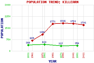
Killearn Classification and Statistics Settlement Type: village Population (2011): 1701 (2001): 1781 (1991): 1816 (1981): 1771 (1971): 1086 (1961): 689 (1881): 356 (1871): 337 (1861): 420 (1831): 388 Tourist Rating: No Text of Entry Updated: 13-JUN-2010 Location Latitude: 56.0431°N Longitude: 4.3726°W National Grid Reference: NS 523 859 A range of modern and historical maps are accessible through the map tab on the right of this page Get directions by entering the UK postcode of your location, home or hotel here eg. EH1 3YT Use the tabs on the right of this page to see other parts of this entry Related Entries There are 28 related entries. (4 Attractions, 1 Council Area, 1 Historical County, 7 Features, 1 Parish, 5 People and 9 Settlements) Names that are not linked do not currently contain any information. Attractions: Glengoyne Distillery New Town Pots of Gartness West Highland Way, The Council Area: Stirling Features: Ballikinrain Castle Blane Water Campsie Fells Carbeth House Finnich Burn Finnich Glen Killearn House Historical Counties: Stirlingshire Parishes: Killearn People: George Buchanan Sir Arnold Clark James Craig Sadie McLellan Sir John Napier Settlements: Balfron Balfron Station Boquhan Croftamie Dumgoyne Edinburgh Fintry Gartness Glasgow
There are 28 related entries. (4 Attractions, 1 Council Area, 1 Historical County, 7 Features, 1 Parish, 5 People and 9 Settlements)
Names that are not linked do not currently contain any information.
By using our site you agree to accept cookies, which help us serve you better