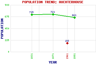
Auchterhouse Classification and Statistics Settlement Type: hamlet Population (1961): 166 (1881): 661 (1871): 721 (1831): 715 Tourist Rating: N/A Text of Entry Updated: 26-AUG-2009 Location Latitude: 56.5247°N Longitude: 3.0874°W National Grid Reference: NO 332 375 A range of modern and historical maps are accessible through the map tab on the right of this page Get directions by entering the UK postcode of your location, home or hotel here eg. EH1 3YT Use the tabs on the right of this page to see other parts of this entry Related Entries There are 17 related entries. (1 Attraction, 1 Council Area, 1 Historical County, 5 Features, 1 Parish, 2 People and 6 Settlements) Names that are not linked do not currently contain any information. Attractions: Auchterhouse Country Sports Council Area: Angus Features: Auchterhouse Bowhouse Hill Round Loch Sidlaw Hills West Mains Hill Historical Counties: Angus Parishes: Auchterhouse People: Rev. Patrick Bell Rev. Prof. Allan Galloway Settlements: Bonnyton Dronley Dundee Kirkton of Auchterhouse North Dronley Piperdam
There are 17 related entries. (1 Attraction, 1 Council Area, 1 Historical County, 5 Features, 1 Parish, 2 People and 6 Settlements)
Names that are not linked do not currently contain any information.
By using our site you agree to accept cookies, which help us serve you better