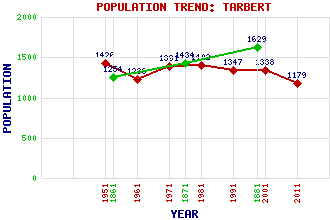
Tarbert Classification and Statistics Settlement Type: village Population (2011): 1179 (2001): 1338 (1991): 1347 (1981): 1402 (1971): 1391 (1961): 1236 (1951): 1426 (1881): 1629 (1871): 1434 (1861): 1254 Tourist Rating: Text of Entry Updated: 27-APR-2007 Location Latitude: 55.8631°N Longitude: 5.415°W National Grid Reference: NR 864 686 A range of modern and historical maps are accessible through the map tab on the right of this page Get directions by entering the UK postcode of your location, home or hotel here eg. EH1 3YT Use the tabs on the right of this page to see other parts of this entry Related Entries There are 36 related entries. (3 Attractions, 1 Council Area, 1 Historical County, 15 Features, 3 Parishes, 2 People and 11 Settlements) Names that are not linked do not currently contain any information. Attractions: Argyll Sea Kayak Trail Kintyre Way Skipness Castle Council Area: Argyll and Bute Features: Barmore Island Ben Arthur Cruach an t-Sorchain Dubh Chreag East Loch Tarbert Kintyre Meall Reamhar Meall Reamhar Mid-Argyll Sliabh Gaoil Stob Odhar Tarbert Academy Tarbert Golf Club Wemyss Bay Railway Station and Ferry Terminal West Loch Tarbert Historical Counties: Argyllshire Parishes: Kilcalmonell North Knapdale Saddell and Skipness People: King James IV Sir Donald MacAlister(1st Baronet of Tarbert) Settlements: Ardlui Ardpatrick Campbeltown Clachan Claonaig Coulaghailtro Kennacraig Portavadie Skipness West Tarbert Whitehouse
There are 36 related entries. (3 Attractions, 1 Council Area, 1 Historical County, 15 Features, 3 Parishes, 2 People and 11 Settlements)
Names that are not linked do not currently contain any information.
By using our site you agree to accept cookies, which help us serve you better