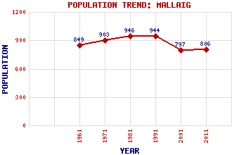
Mallaig Classification and Statistics Settlement Type: village Population (2011): 806 (2001): 797 (1991): 944 (1981): 946 (1971): 903 (1961): 849 Tourist Rating: Text of Entry Updated: 25-MAY-2020 Location Latitude: 57.0036°N Longitude: 5.8303°W National Grid Reference: NM 675 968 A range of modern and historical maps are accessible through the map tab on the right of this page Get directions by entering the UK postcode of your location, home or hotel here eg. EH1 3YT Use the tabs on the right of this page to see other parts of this entry Related Entries There are 65 related entries. (11 Attractions, 1 Council Area, 1 Historical County, 27 Features, 1 Parish, 2 People and 22 Settlements) Names that are not linked do not currently contain any information. Attractions: Canna Eigg Glenfinnan Station Museum Glenfinnan Viaduct Mallaig Heritage Centre Mallaig Marine World Muck Road to the Isles, The Rum Skye West Highland Line Council Area: Highland Features: Airor Island Arisaig Arisaig Railway Station Barra Barrisdale Bay Beasdale Railway Station Carn a' Mhadaidh-ruaidh Dalreoch Railway Bridge Druim a' Chuirn Knoydart Mallaig Harbour Mallaig High School Mallaig Railway Station Morar Bay Morar Power Station Morar, Loch Nevis, Loch North Morar Rough Bounds, The Sgurr Bhuidhe Sgurr Eireagoraidh Sgurr an Eilein Ghiubhais Sleat Sleat, Sound of Small Isles South Uist Traigh House Historical Counties: Inverness-shire Parishes: Glenelg People: Prof. (Thomas) Graham Brown Prince Charles Edward Stuart(Bonnie Prince Charlie) Settlements: Acharacle Arisaig Armadale Beoraidbeg Bracora Courteachan Doune Fort William Glenfinnan Helensburgh Inverie Lochailort Lochboisdale Lochyside Mallaigvaig Morar Oban Portree Sandaig Stornoway Tarbet Ullapool
There are 65 related entries. (11 Attractions, 1 Council Area, 1 Historical County, 27 Features, 1 Parish, 2 People and 22 Settlements)
Names that are not linked do not currently contain any information.
By using our site you agree to accept cookies, which help us serve you better