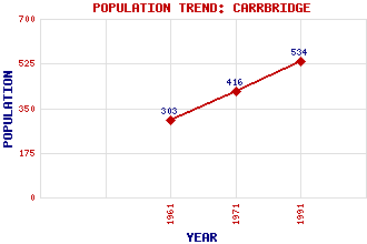
Carrbridge Classification and Statistics Settlement Type: village Population (1991): 534 (1971): 416 (1961): 303 Tourist Rating: Text of Entry Updated: 10-MAR-2020 Location Latitude: 57.2835°N Longitude: 3.8164°W National Grid Reference: NH 906 229 A range of modern and historical maps are accessible through the map tab on the right of this page Get directions by entering the UK postcode of your location, home or hotel here eg. EH1 3YT Use the tabs on the right of this page to see other parts of this entry Related Entries There are 23 related entries. (1 Attraction, 1 Council Area, 1 Historical County, 1 Family, 11 Features, 1 Parish, 1 Person and 6 Settlements) Names that are not linked do not currently contain any information. Attractions: Landmark Highland Heritage Park Council Area: Highland Families: Grant Features: A9 Trunk Road Braigh Bhruthaich, Loch Carn Glas-choire Carrbridge Railway Station Dulnain, River Lochindorb Lorgy, Allt Slochd Beag Slochd Summit Spey, River Stuirteag, Loch nan Historical Counties: Inverness-shire Parishes: Duthil and Rothiemurchus People: Prince Charles Edward Stuart(Bonnie Prince Charlie) Settlements: Aviemore Bogroy Dalnahaitnach Grantown on Spey Inverness Slochd
There are 23 related entries. (1 Attraction, 1 Council Area, 1 Historical County, 1 Family, 11 Features, 1 Parish, 1 Person and 6 Settlements)
Names that are not linked do not currently contain any information.
By using our site you agree to accept cookies, which help us serve you better