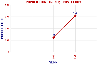
Castlebay (Bagh a' Chaisteil) Classification and Statistics Settlement Type: village Population (1971): 307 (1961): 122 Tourist Rating: No Text of Entry Updated: 10-DEC-2008 Location Latitude: 56.9544°N Longitude: 7.4864°W National Grid Reference: NL 666 982 A range of modern and historical maps are accessible through the map tab on the right of this page Get directions by entering the UK postcode of your location, home or hotel here eg. EH1 3YT Use the tabs on the right of this page to see other parts of this entry Related Entries There are 56 related entries. (7 Attractions, 1 Council Area, 1 Historical County, 1 Family, 24 Features, 1 Parish, 0 People and 21 Settlements) Names that are not linked do not currently contain any information. Attractions: Barra Heritage and Cultural Centre Barra War Memorial Cockle Strand Airport Isle of Barra Golf Course Kisimul Castle Liniclate Community School MacLeod's Tower Council Area: Western Isles Families: MacNeil Features: Barra Beag, Bagh Ben Gunnary Ben Leribreck Ben Obe Ben Tangaval Caragrich Point Castle Bay Castle Sinclair Castlebay Community School Curachan Doirlinn Head Greian Head Grianan Halaman Bay Hartaval Heaval Heishival More Hirivagh, Bay Muldoanich Orosay Our Lady Star of the Sea St Brendan's Hospital Tangasdale, Loch Historical Counties: Inverness-shire Parishes: Barra Settlements: Ardveenish Balnabodach Borve Brevig Bruernish Cleat Craigston Cuier Earsary Garrygall Glen Greian Kentangaval Kinloch Ledaig Nask Northbay Saltinish Skallary Tangusdale Uidh
There are 56 related entries. (7 Attractions, 1 Council Area, 1 Historical County, 1 Family, 24 Features, 1 Parish, 0 People and 21 Settlements)
Names that are not linked do not currently contain any information.
By using our site you agree to accept cookies, which help us serve you better