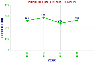
Hownam Classification and Statistics Settlement Type: village Population (1881): 263 (1871): 238 (1861): 289 (1831): 260 Tourist Rating: N/A Text of Entry Updated: 25-MAY-2020 Location Latitude: 55.4652°N Longitude: 2.3526°W National Grid Reference: NT 778 191 A range of modern and historical maps are accessible through the map tab on the right of this page Get directions by entering the UK postcode of your location, home or hotel here eg. EH1 3YT Use the tabs on the right of this page to see other parts of this entry Related Entries There are 14 related entries. (1 Attraction, 1 Council Area, 1 Historical County, 8 Features, 1 Parish, 0 People and 2 Settlements) Names that are not linked do not currently contain any information. Attractions: Hownam Rings Council Area: Scottish Borders Features: Cheviot Hills, The Cunzierton Hill Heugh Law Hownam Law Kale Water Loddan Hill Shibden Hill Thowliestane Hill Historical Counties: Roxburghshire Parishes: Hownam Settlements: Jedburgh Town Yetholm
There are 14 related entries. (1 Attraction, 1 Council Area, 1 Historical County, 8 Features, 1 Parish, 0 People and 2 Settlements)
Names that are not linked do not currently contain any information.
By using our site you agree to accept cookies, which help us serve you better