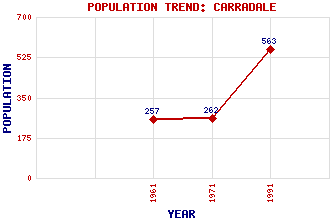
Carradale Classification and Statistics Settlement Type: village Population (1991): 563 (1971): 262 (1961): 257 Tourist Rating: Yes Text of Entry Updated: 25-AUG-2006 Location Latitude: 55.5891°N Longitude: 5.4689°W National Grid Reference: NR 815 383 A range of modern and historical maps are accessible through the map tab on the right of this page Get directions by entering the UK postcode of your location, home or hotel here eg. EH1 3YT Use the tabs on the right of this page to see other parts of this entry Related Entries There are 22 related entries. (1 Attraction, 1 Council Area, 1 Historical County, 9 Features, 1 Parish, 3 People and 6 Settlements) Names that are not linked do not currently contain any information. Attractions: Kintyre Way Council Area: Argyll and Bute Features: Airds Castle Beinn an Tuirc Beinn an Tuirc Wind Farm Carradale Bay Carradale Forest Carradale Point Deucheran Hill Wind Farm Kintyre Torrisdale Castle Historical Counties: Argyllshire Parishes: Saddell and Skipness People: John Campbell Mitchell Naomi Mitchison Prof. Alexander Thom Settlements: Bridgend Campbeltown Dippen Grogport Saddell Waterfoot
There are 22 related entries. (1 Attraction, 1 Council Area, 1 Historical County, 9 Features, 1 Parish, 3 People and 6 Settlements)
Names that are not linked do not currently contain any information.
By using our site you agree to accept cookies, which help us serve you better