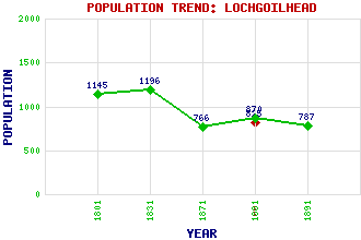
Lochgoilhead Classification and Statistics Settlement Type: village Population (1991): 825 (1891): 787(For parish) (1881): 870(For parish) (1871): 766(For parish) (1831): 1196(For parish) (1801): 1145(For parish) Tourist Rating: N/A Text of Entry Updated: 03-OCT-2011 Location Latitude: 56.1702°N Longitude: 4.9024°W National Grid Reference: NN 199 013 A range of modern and historical maps are accessible through the map tab on the right of this page Get directions by entering the UK postcode of your location, home or hotel here eg. EH1 3YT Use the tabs on the right of this page to see other parts of this entry Related Entries There are 21 related entries. (2 Attractions, 1 Council Area, 1 Historical County, 13 Features, 1 Parish, 1 Person and 2 Settlements) Names that are not linked do not currently contain any information. Attractions: Drimsynie Hotel and Estate European Sheep and Wool Centre Council Area: Argyll and Bute Features: Ardgoil Beinn Lochain Beinn Reithe Beinn Tharsuinn Ben Donich Cowal Goil, Glen Goil, Loch Hell's Glen Lochgoilhead Golf Club Mor, Gleann Stob an Eas Stob na Boine Druim-fhinn Historical Counties: Argyllshire Parishes: Lochgoilhead and Kilmorich People: Alan Johnston Settlements: Corrow Whistlefield
There are 21 related entries. (2 Attractions, 1 Council Area, 1 Historical County, 13 Features, 1 Parish, 1 Person and 2 Settlements)
Names that are not linked do not currently contain any information.
By using our site you agree to accept cookies, which help us serve you better