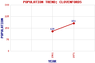
Clovenfords Classification and Statistics Settlement Type: hamlet Population (1971): 181 (1961): 129 Tourist Rating: N/A Text of Entry Updated: 18-SEP-2003 Location Latitude: 55.618°N Longitude: 2.8779°W National Grid Reference: NT 448 364 A range of modern and historical maps are accessible through the map tab on the right of this page Get directions by entering the UK postcode of your location, home or hotel here eg. EH1 3YT Use the tabs on the right of this page to see other parts of this entry Related Entries There are 13 related entries. (0 Attractions, 1 Council Area, 1 Historical County, 7 Features, 1 Parish, 1 Person and 2 Settlements) Names that are not linked do not currently contain any information. Council Area: Scottish Borders Features: Ashiestiel Bridge Bowland Bridge Caddon Water Knowesdean Reservoir Peel House Stantling Craig Reservoir Whytbank Tower Historical Counties: Selkirkshire Parishes: Caddonfoot People: Sir Walter Scott Settlements: Ashiestiel Galashiels
There are 13 related entries. (0 Attractions, 1 Council Area, 1 Historical County, 7 Features, 1 Parish, 1 Person and 2 Settlements)
Names that are not linked do not currently contain any information.
By using our site you agree to accept cookies, which help us serve you better