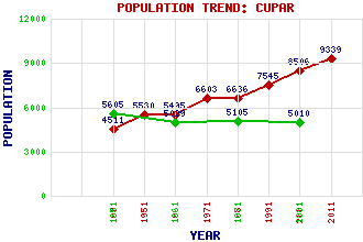
Cupar Classification and Statistics Settlement Type: small town Population (2011): 9339 (2001): 8506 (1991): 7545 (1981): 6636 (1971): 6603 (1961): 5495 (1951): 5530 (1901): 4511(Parliamentary Burgh) (1881): 5010 (1871): 5105 (1861): 5029 (1851): 5605 Tourist Rating: Text of Entry Updated: 24-JUL-2015 Location Latitude: 56.3196°N Longitude: 3.0136°W National Grid Reference: NO 374 146 A range of modern and historical maps are accessible through the map tab on the right of this page Get directions by entering the UK postcode of your location, home or hotel here eg. EH1 3YT References and Further Reading Turnbull, W. Hogarth (1911) The Story of the Lomond Vale. J. & G. Innes, Cupar Use the tabs on the right of this page to see other parts of this entry Related Entries There are 130 related entries. (9 Attractions, 1 Council Area, 1 Historical County, 23 Features, 35 Parishes, 17 People and 44 Settlements) Names that are not linked do not currently contain any information. Attractions: Aberfeldy Water Mill Cross, The Cupar Parish Church David Crichton Statue Haugh Park Praytis Country Park Scottish Deer Centre Sir Douglas Bader Garden for the Disabled Tarvit, Hill of Council Area: Fife Features: Bell Baxter High School Church of St James the Great Clatto Reservoir Craigsanquhar House Crawford Priory Cupar Railway Station Dura Den East Coast Main Line Eden, River Elmwood Golf Course Fernie Castle Fife College Fife County Buildings Foodie Hill Hopetoun Monument Howe of Fife Kilmaron Castle Kilmaron Hill Kilmaron School Leven Bus Station Mount Hill Murdochcairnie Hill SRUC Elmwood Campus Historical Counties: Fife Parishes: Abdie Anstruther Easter Anstruther Wester Cameron Carnbee Ceres Collessie Crail Creich Cults Cupar Cupar Dairsie Dunbog Dunino Elie Flisk Kemback Kennoway Kettle Kilconquhar Kilmany Kilrenny Kingsbarns Largo Logie Markinch Monimail Moonzie Newburgh Newburn Pittenweem Scoonie St Andrews and St Leonards St Monance People: Colonel Robert Hope Moncrieff Aitken David Annand Rev. Dr. Andrew Bell Alexander Berry John Campbell(Lord Campbell) Sir George Deas(Lord Deas) Henry (Harry) Snell Gamley(H.S. Gamley) Sir John Edward Gilmour King James V Charles Alfred Jarvis Sir David Lindsay Vincenzo Lunardi Admiral Sir Frederick Lewis Maitland Nina Myskow Alexander Nimmo Sir Robert Sibbald William Wallace Settlements: Auchtermuchty Baintown Baldinnie Blebo Bonnybank Bow of Fife Bridgend Burnside Ceres Chance Inn Collessie Cowdenbeath Craigrothie Cupar Muir Dairsie Dunbog Dura Foodieash Glenduckie Glenrothes Guardbridge Hazelton Walls Kemback Kettlebridge Kettlehill Kilmany Kilmaron Kingskettle Ladybank Lordscairnie Montrave Moonzie Newburgh Parbroath Pettycur Pitlessie Pitscottie Rankeilour Rathillet Springfield St Andrews Stratheden Struthers Woodside
There are 130 related entries. (9 Attractions, 1 Council Area, 1 Historical County, 23 Features, 35 Parishes, 17 People and 44 Settlements)
Names that are not linked do not currently contain any information.
By using our site you agree to accept cookies, which help us serve you better