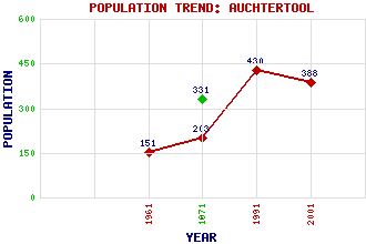
Auchtertool Classification and Statistics Settlement Type: village Population (2001): 388 (1991): 430 (1971): 203 (1961): 151 (1871): 331(With Newbigging) Tourist Rating: No Text of Entry Updated: 19-FEB-2002 Location Latitude: 56.1017°N Longitude: 3.2603°W National Grid Reference: NT 217 906 A range of modern and historical maps are accessible through the map tab on the right of this page Get directions by entering the UK postcode of your location, home or hotel here eg. EH1 3YT Use the tabs on the right of this page to see other parts of this entry Related Entries There are 17 related entries. (0 Attractions, 1 Council Area, 1 Historical County, 5 Features, 1 Parish, 1 Person and 8 Settlements) Names that are not linked do not currently contain any information. Council Area: Fife Features: Auchterderran Parish Balmuto Castle Camilla Loch Gelly, Loch Hallyards Castle Historical Counties: Fife Parishes: Auchtertool People: King James V Settlements: Cowdenbeath Dunfermline Dunkeld Kinghorn Kirkcaldy Kirkton Newbigging Perth
There are 17 related entries. (0 Attractions, 1 Council Area, 1 Historical County, 5 Features, 1 Parish, 1 Person and 8 Settlements)
Names that are not linked do not currently contain any information.
By using our site you agree to accept cookies, which help us serve you better