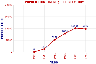
Dalgety Bay Classification and Statistics Settlement Type: small town Population (2011): 9874 (2001): 10011 (1991): 7860 (1981): 5276 (1971): 1275 (1961): 26 Tourist Rating: Text of Entry Updated: 30-JUN-2007 Location Latitude: 56.0323°N Longitude: 3.3624°W National Grid Reference: NT 152 830 A range of modern and historical maps are accessible through the map tab on the right of this page Get directions by entering the UK postcode of your location, home or hotel here eg. EH1 3YT Use the tabs on the right of this page to see other parts of this entry Related Entries There are 24 related entries. (2 Attractions, 1 Council Area, 1 Historical County, 13 Features, 1 Parish, 1 Person and 5 Settlements) Names that are not linked do not currently contain any information. Attractions: Fife Coastal Path Forth Road Bridge Council Area: Fife Features: Braefoot Bay Braefoot Bay Marine Terminal Couston Castle Dalgety Bay Dalgety Bay Railway Station Donibristle Donibristle Bay East Coast Main Line Fordell Burn Fordell Castle Forth, Firth of Inverkeithing Bay Otterston Loch Historical Counties: Fife Parishes: Dalgety People: Sir Alexander Seton(1st Earl of Dunfermline) Settlements: Aberdour Inverkeithing North Queensferry St David's Harbour St Davids
There are 24 related entries. (2 Attractions, 1 Council Area, 1 Historical County, 13 Features, 1 Parish, 1 Person and 5 Settlements)
Names that are not linked do not currently contain any information.
By using our site you agree to accept cookies, which help us serve you better