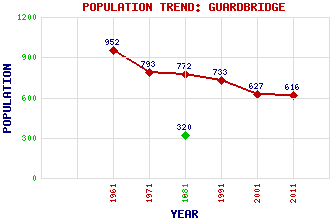
Guardbridge Classification and Statistics Settlement Type: village Population (2011): 616 (2001): 627 (1991): 733 (1981): 772 (1971): 793 (1961): 952 (1881): 320 Tourist Rating: No Text of Entry Updated: 20-JUN-2013 Location Latitude: 56.3646°N Longitude: 2.8918°W National Grid Reference: NO 450 195 A range of modern and historical maps are accessible through the map tab on the right of this page Get directions by entering the UK postcode of your location, home or hotel here eg. EH1 3YT Use the tabs on the right of this page to see other parts of this entry Related Entries There are 15 related entries. (0 Attractions, 1 Council Area, 1 Historical County, 1 Family, 6 Features, 1 Parish, 0 People and 5 Settlements) Names that are not linked do not currently contain any information. Council Area: Fife Families: Haig Features: Eden Estuary Eden Estuary Centre Eden, River Guard Bridge Motray Water University of St Andrews Historical Counties: Fife Parishes: Leuchars Settlements: Cupar Dundee Kincaple Leuchars St Andrews
There are 15 related entries. (0 Attractions, 1 Council Area, 1 Historical County, 1 Family, 6 Features, 1 Parish, 0 People and 5 Settlements)
Names that are not linked do not currently contain any information.
By using our site you agree to accept cookies, which help us serve you better