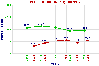
Drymen Classification and Statistics Settlement Type: village Population (2011): 820 (2001): 681 (1991): 844 (1981): 780 (1971): 659 (1961): 474 (1881): 1431(For parish) (1871): 1405(For parish) (1861): 1619(For parish) (1831): 1690(For parish) (1801): 1607(For parish) Tourist Rating: N/A Text of Entry Updated: 30-APR-2002 Location Latitude: 56.0658°N Longitude: 4.4511°W National Grid Reference: NS 475 886 A range of modern and historical maps are accessible through the map tab on the right of this page Get directions by entering the UK postcode of your location, home or hotel here eg. EH1 3YT Use the tabs on the right of this page to see other parts of this entry Related Entries There are 23 related entries. (3 Attractions, 1 Council Area, 1 Historical County, 1 Family, 7 Features, 1 Parish, 1 Person and 8 Settlements) Names that are not linked do not currently contain any information. Attractions: Loch Lomond and the Trossachs National Park Rob Roy Way West Highland Way, The Council Area: Stirling Families: Graham Features: Buchanan Castle Catter Burn Endrick Water Lomond, Loch Ross Priory Strathendrick Strathendrick Golf Club Historical Counties: Stirlingshire Parishes: Drymen People: Charles George Hood Kinnear Settlements: Balmaha Buchanan Smithy Croftamie Dumbarton Glasgow Milton of Buchanan Montrose Stirling
There are 23 related entries. (3 Attractions, 1 Council Area, 1 Historical County, 1 Family, 7 Features, 1 Parish, 1 Person and 8 Settlements)
Names that are not linked do not currently contain any information.
By using our site you agree to accept cookies, which help us serve you better