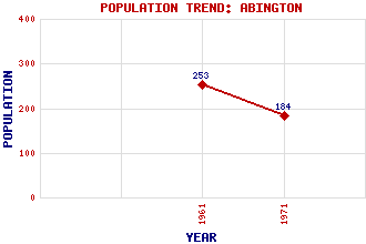
Abington Classification and Statistics Settlement Type: settlement Population (1971): 184 (1961): 253 Tourist Rating: No Text of Entry Updated: 06-MAY-2019 Location Latitude: 55.4926°N Longitude: 3.6935°W National Grid Reference: NS 931 234 A range of modern and historical maps are accessible through the map tab on the right of this page Get directions by entering the UK postcode of your location, home or hotel here eg. EH1 3YT Use the tabs on the right of this page to see other parts of this entry Related Entries There are 31 related entries. (0 Attractions, 1 Council Area, 1 Historical County, 18 Features, 1 Parish, 1 Person and 9 Settlements) Names that are not linked do not currently contain any information. Council Area: South Lanarkshire Features: A74(M) Motorway Black Hill Castle Hill Clyde Wind Farm North Clyde, River Coomb Dod Craighead Hill Culter Cleuch Shank Duncangill Head Duneaton Water Forside Hill Glencaple Burn Mill Burn Raggengill Hill Ravengill Dod Tewsgill Hill West Coast Main Line White Hill Historical Counties: Lanarkshire Parishes: Crawfordjohn People: William (Willie) Fernie Settlements: Biggar Crawford Crawfordjohn Edinburgh Glasgow Leadhills Lettershaws Roberton Wandel
There are 31 related entries. (0 Attractions, 1 Council Area, 1 Historical County, 18 Features, 1 Parish, 1 Person and 9 Settlements)
Names that are not linked do not currently contain any information.
By using our site you agree to accept cookies, which help us serve you better