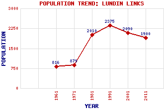
Lundin Links Classification and Statistics Settlement Type: village Population (2011): 1900 (Combined with Lower Largo) (2001): 2090 (1991): 2375 (1981): 2010(Combined with Lower Largo) (1971): 879 (1961): 816 Tourist Rating: Text of Entry Updated: 03-AUG-2017 Location Latitude: 56.2122°N Longitude: 2.956°W National Grid Reference: NO 408 026 A range of modern and historical maps are accessible through the map tab on the right of this page Get directions by entering the UK postcode of your location, home or hotel here eg. EH1 3YT Use the tabs on the right of this page to see other parts of this entry Related Entries There are 14 related entries. (1 Attraction, 1 Council Area, 1 Historical County, 1 Family, 5 Features, 1 Parish, 2 People and 2 Settlements) Names that are not linked do not currently contain any information. Attractions: Fife Coastal Path Council Area: Fife Families: Lundy Features: Aithernie Castle Aithernie House East Neuk of Fife Hatton Burn Lundin Golf Course Historical Counties: Fife Parishes: Largo People: (George) Leslie Hunter(G.L. Hunter) William Ritchie Settlements: Lower Largo Teasses
There are 14 related entries. (1 Attraction, 1 Council Area, 1 Historical County, 1 Family, 5 Features, 1 Parish, 2 People and 2 Settlements)
Names that are not linked do not currently contain any information.
By using our site you agree to accept cookies, which help us serve you better