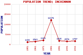
Inchinnan Classification and Statistics Settlement Type: village Population (2011): 1797 (2001): 1574 (1991): 1815 (1981): 12176 (1971): 2143 (1961): 1543 (1951): 1193 Tourist Rating: N/A Text of Entry Updated: 22-JAN-2007 Location Latitude: 55.89°N Longitude: 4.4352°W National Grid Reference: NS 478 690 A range of modern and historical maps are accessible through the map tab on the right of this page Get directions by entering the UK postcode of your location, home or hotel here eg. EH1 3YT Use the tabs on the right of this page to see other parts of this entry Related Entries There are 17 related entries. (1 Attraction, 1 Council Area, 1 Historical County, 4 Features, 1 Parish, 6 People and 3 Settlements) Names that are not linked do not currently contain any information. Attractions: Museum of Flight, The Council Area: Renfrewshire Features: Barnsford Bridge Clyde, River Freeland M8 Motorway Historical Counties: Renfrewshire Parishes: Inchinnan People: Sir William Beardmore(Baron Invernairn) Prof. Douglas Dunn Saint Inan(St. Inan. St. Evan) Saint Kentigern(St. Kentigern or St. Mungo) Andrew Melville Douglas (Dougie) Vipond Settlements: Erskine Hillington Paisley
There are 17 related entries. (1 Attraction, 1 Council Area, 1 Historical County, 4 Features, 1 Parish, 6 People and 3 Settlements)
Names that are not linked do not currently contain any information.
By using our site you agree to accept cookies, which help us serve you better