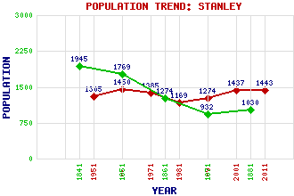
Stanley Classification and Statistics Settlement Type: village Population (2011): 1443 (2001): 1437 (1991): 1274 (1981): 1169 (1971): 1385 (1961): 1450 (1951): 1305 (1881): 1030 (1871): 932 (1861): 1274 (1851): 1769 (1841): 1945 Tourist Rating: N/A Text of Entry Updated: 05-MAY-2020 Location Latitude: 56.4824°N Longitude: 3.4467°W National Grid Reference: NO 109 332 A range of modern and historical maps are accessible through the map tab on the right of this page Get directions by entering the UK postcode of your location, home or hotel here eg. EH1 3YT References and Further Reading Cooke, Anthony (2015) Stanley: From Arkwright Village to Commuter Suburb 1784 - 2015. Grace Note Publications, Ochtertyre Use the tabs on the right of this page to see other parts of this entry Related Entries There are 18 related entries. (3 Attractions, 1 Council Area, 1 Historical County, 4 Features, 1 Parish, 5 People and 3 Settlements) Names that are not linked do not currently contain any information. Attractions: Over Benchil Standing Stone Stanley Mills Stanley Mills Power Station Council Area: Perth and Kinross Features: Benchil Burn Highland Line Inchbervis Castle Tay, River Historical Counties: Perthshire Parishes: Auchtergaven People: David Dale George Dempster of Dunnichen(Honest George) John Murray(1st Marquess and 5th Earl of Atholl) John Murray(4th Duke of Atholl) John Robertson Settlements: Dunnichen Perth West Tofts
There are 18 related entries. (3 Attractions, 1 Council Area, 1 Historical County, 4 Features, 1 Parish, 5 People and 3 Settlements)
Names that are not linked do not currently contain any information.
By using our site you agree to accept cookies, which help us serve you better