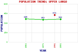
Upper Largo (Kirkton of Largo) Classification and Statistics Settlement Type: village Population (1991): 430 (1881): 362 (1871): 353 (1861): 365 Tourist Rating: Text of Entry Updated: 09-AUG-2006 Location Latitude: 56.2205°N Longitude: 2.9304°W National Grid Reference: NO 424 035 A range of modern and historical maps are accessible through the map tab on the right of this page Get directions by entering the UK postcode of your location, home or hotel here eg. EH1 3YT References and Further Reading Lister, Rev. Douglas and James Gillies (1968) The Story of Largo Kirk. Use the tabs on the right of this page to see other parts of this entry Related Entries There are 14 related entries. (0 Attractions, 1 Council Area, 1 Historical County, 3 Features, 1 Parish, 4 People and 4 Settlements) Names that are not linked do not currently contain any information. Council Area: Fife Features: East Neuk of Fife Largo Law Pitcruvie Castle Historical Counties: Fife Parishes: Largo People: Prof. Sir John Leslie Robert Mylne Alexander Selkirk Sir Andrew Wood Settlements: Largoward Lower Largo New Gilston Woodside
There are 14 related entries. (0 Attractions, 1 Council Area, 1 Historical County, 3 Features, 1 Parish, 4 People and 4 Settlements)
Names that are not linked do not currently contain any information.
By using our site you agree to accept cookies, which help us serve you better