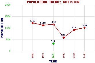
Wattston Classification and Statistics Settlement Type: village Population (2011): 1004 (Combined with Greengairs) (2001): 920(Combined with Greengairs) (1991): 578(Combined with Greengairs) (1981): 1158(Combined with Greengairs) (1971): 1118(Combined with Greengairs) (1961): 1212(Combined with Greengairs) (1881): 324 Tourist Rating: N/A Text of Entry Updated: 19-APR-2011 Location Latitude: 55.9075°N Longitude: 3.9595°W National Grid Reference: NS 776 700 A range of modern and historical maps are accessible through the map tab on the right of this page Get directions by entering the UK postcode of your location, home or hotel here eg. EH1 3YT References and Further Reading Smith, Robin (2001) The Making of Scotland. Canongate Books Ltd, Edinburgh Use the tabs on the right of this page to see other parts of this entry Related Entries There are 7 related entries. (0 Attractions, 1 Council Area, 1 Historical County, 0 Features, 1 Parish, 0 People and 4 Settlements) Names that are not linked do not currently contain any information. Council Area: North Lanarkshire Historical Counties: Lanarkshire Parishes: New Monkland Settlements: Airdrie Cumbernauld Greengairs Riggend
There are 7 related entries. (0 Attractions, 1 Council Area, 1 Historical County, 0 Features, 1 Parish, 0 People and 4 Settlements)
Names that are not linked do not currently contain any information.
By using our site you agree to accept cookies, which help us serve you better