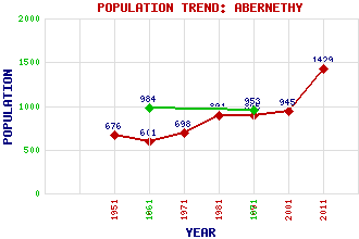
Abernethy Classification and Statistics Settlement Type: village Population (2011): 1429 (2001): 945 (1991): 895 (1981): 891 (1971): 698 (1961): 601 (1951): 676 (1871): 953 (1861): 984 Tourist Rating: No Text of Entry Updated: 18-SEP-2003 Location Latitude: 56.333°N Longitude: 3.3132°W National Grid Reference: NO 189 164 A range of modern and historical maps are accessible through the map tab on the right of this page Get directions by entering the UK postcode of your location, home or hotel here eg. EH1 3YT Use the tabs on the right of this page to see other parts of this entry Related Entries There are 24 related entries. (2 Attractions, 1 Council Area, 1 Historical County, 12 Features, 1 Parish, 2 People and 5 Settlements) Names that are not linked do not currently contain any information. Attractions: Abernethy Round Tower Museum of Abernethy, The Council Area: Perth and Kinross Features: Abernethy Glen Abernethy Hill Binn Hill Castle Law Earn, Strath Farg, River Lochmill Loch Lumbennie Hill Pitcairley Hill Pitmedden Forest Strathspey Tay, River Historical Counties: Perthshire Parishes: Abernethy People: Rev. John Brown King Malcolm III(Malcolm Canmore) Settlements: Aberargie Brechin Glenfoot Newburgh Pitkeathly Wells
There are 24 related entries. (2 Attractions, 1 Council Area, 1 Historical County, 12 Features, 1 Parish, 2 People and 5 Settlements)
Names that are not linked do not currently contain any information.
By using our site you agree to accept cookies, which help us serve you better