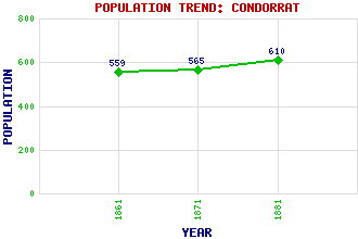
Condorrat Classification and Statistics Settlement Type: suburb Population (1881): 610 (1871): 565 (1861): 559 Tourist Rating: N/A Text of Entry Updated: 24-MAR-2016 Location Latitude: 55.9361°N Longitude: 4.0186°W National Grid Reference: NS 740 733 A range of modern and historical maps are accessible through the map tab on the right of this page Get directions by entering the UK postcode of your location, home or hotel here eg. EH1 3YT Use the tabs on the right of this page to see other parts of this entry Related Entries There are 13 related entries. (0 Attractions, 1 Council Area, 1 Historical County, 1 Event, 3 Features, 1 Parish, 1 Person and 5 Settlements) Names that are not linked do not currently contain any information. Council Area: North Lanarkshire Events: Radical Rising Features: Low Wood Junction Luggie Water St Maurice's High School Historical Counties: Dunbartonshire Parishes: Cumbernauld People: John Baird Settlements: Annathill Cumbernauld Dalshannon Eastfield Westfield
There are 13 related entries. (0 Attractions, 1 Council Area, 1 Historical County, 1 Event, 3 Features, 1 Parish, 1 Person and 5 Settlements)
Names that are not linked do not currently contain any information.
By using our site you agree to accept cookies, which help us serve you better