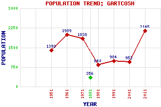
Gartcosh Classification and Statistics Settlement Type: village Population (2011): 2145 (2001): 952 (1991): 984 (1981): 840 (1971): 1838 (1961): 1989 (1951): 1393 (1881): 356 Tourist Rating: N/A Text of Entry Updated: 03-MAR-2016 Location Latitude: 55.8891°N Longitude: 4.0824°W National Grid Reference: NS 698 681 A range of modern and historical maps are accessible through the map tab on the right of this page Get directions by entering the UK postcode of your location, home or hotel here eg. EH1 3YT Use the tabs on the right of this page to see other parts of this entry Related Entries There are 27 related entries. (10 Attractions, 1 Council Area, 1 Historical County, 8 Features, 1 Parish, 0 People and 6 Settlements) Names that are not linked do not currently contain any information. Attractions: Craigmillar Castle Drumlanrig Castle Duart Castle Dunollie Castle Inveraray Castle Kildrummy Castle Linlithgow Palace Lochmaben Castle Scalloway Castle Threave Castle Council Area: North Lanarkshire Features: Bishop Loch Borthwick Castle Gartcosh Railway Station Johnston Loch M73 Motorway Scottish Crime Campus Skibo Castle Urquhart Castle Historical Counties: Lanarkshire Parishes: Cadder Settlements: Coatbridge Cumbernauld Glasgow Heathfield Marnock Muirhead
There are 27 related entries. (10 Attractions, 1 Council Area, 1 Historical County, 8 Features, 1 Parish, 0 People and 6 Settlements)
Names that are not linked do not currently contain any information.
By using our site you agree to accept cookies, which help us serve you better