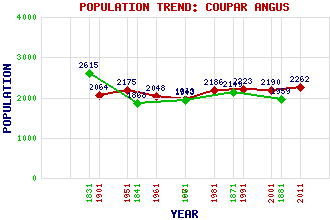
Coupar Angus Classification and Statistics Settlement Type: village Population (2011): 2262 (2001): 2190 (1991): 2223 (1981): 2186 (1971): 1963 (1961): 2048 (1951): 2175 (1901): 2064(Police Burgh) (1881): 1959 (1871): 2149 (1861): 1943 (1841): 1868 (1831): 2615 Tourist Rating: Text of Entry Updated: 02-OCT-2023 Location Latitude: 49.2631°N Longitude: 37.2403°E National Grid Reference: N 212 402 A range of modern and historical maps are accessible through the map tab on the right of this page Get directions by entering the UK postcode of your location, home or hotel here eg. EH1 3YT Use the tabs on the right of this page to see other parts of this entry Related Entries There are 33 related entries. (4 Attractions, 1 Council Area, 1 Historical County, 11 Features, 1 Parish, 3 People and 12 Settlements) Names that are not linked do not currently contain any information. Attractions: Coupar Angus Abbey Gatehouse Ledyatt Loch Meigle Sculptured Stone Museum, The Tummel Suspension Bridge Council Area: Perth and Kinross Features: Arthurstone House Backwater Reservoir Balshando Loch Butterstone, Loch of Dores, Hill of Ericht, River Hallyburton House Isla, Glen Lunan Burn Northballo Hill Strathmore, Valley of Historical Counties: Perthshire Parishes: Bendochy People: Donald Cargill King Malcolm IV(Malcolm the Maiden) Thomas Meik Settlements: Ardler Balholmie Burrelton Cargill Collace Eassie Fonab Keithick Kettins Newtyle Pitcur Tullybaccart
There are 33 related entries. (4 Attractions, 1 Council Area, 1 Historical County, 11 Features, 1 Parish, 3 People and 12 Settlements)
Names that are not linked do not currently contain any information.
By using our site you agree to accept cookies, which help us serve you better