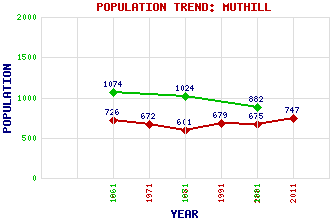
Muthill Classification and Statistics Settlement Type: village Population (2011): 747 (2001): 675 (1991): 679 (1981): 601 (1971): 672 (1961): 726 (1881): 882 (1871): 1024 (1861): 1074 Tourist Rating: Text of Entry Updated: 09-AUG-2009 Location Latitude: 56.3299°N Longitude: 3.8339°W National Grid Reference: NN 867 168 A range of modern and historical maps are accessible through the map tab on the right of this page Get directions by entering the UK postcode of your location, home or hotel here eg. EH1 3YT Use the tabs on the right of this page to see other parts of this entry Related Entries There are 14 related entries. (2 Attractions, 1 Council Area, 1 Historical County, 3 Features, 1 Parish, 5 People and 1 Settlement) Names that are not linked do not currently contain any information. Attractions: Drummond Castle Muthill Old Church and Tower Council Area: Perth and Kinross Features: Drummond, Pond of Earn, Strath Muthill Golf Club, The Historical Counties: Perthshire Parishes: Muthill People: John Barclay Thomas Cadell David Mallet(David Malloch) Arabella Louisa Rankin Sir James Lawton Wingate Settlements: Mill of Drummond
There are 14 related entries. (2 Attractions, 1 Council Area, 1 Historical County, 3 Features, 1 Parish, 5 People and 1 Settlement)
Names that are not linked do not currently contain any information.
By using our site you agree to accept cookies, which help us serve you better