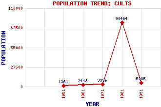
Cults Classification and Statistics Settlement Type: small town Population (1991): 5265 (1981): 90464(Combined with Aberdeen) (1971): 3336 (1961): 2448 (1951): 1361 Tourist Rating: No Text of Entry Updated: 23-JUL-2019 Location Latitude: 57.1187°N Longitude: 2.1733°W National Grid Reference: NJ 896 031 A range of modern and historical maps are accessible through the map tab on the right of this page Get directions by entering the UK postcode of your location, home or hotel here eg. EH1 3YT Use the tabs on the right of this page to see other parts of this entry Related Entries There are 16 related entries. (0 Attractions, 1 Council Area, 1 Historical County, 10 Features, 1 Parish, 0 People and 3 Settlements) Names that are not linked do not currently contain any information. Council Area: Aberdeen City Features: Ardoe House Culter Burn Cults Academy Dee, River Freedom Lands of Aberdeen Garthdee Inchgarth Nature Reserve Inchgarth Reservoir Slopefield Reservoir St Devenick's Bridge Historical Counties: Aberdeenshire Parishes: Peterculter Settlements: Aberdeen Ardoe Bieldside
There are 16 related entries. (0 Attractions, 1 Council Area, 1 Historical County, 10 Features, 1 Parish, 0 People and 3 Settlements)
Names that are not linked do not currently contain any information.
By using our site you agree to accept cookies, which help us serve you better