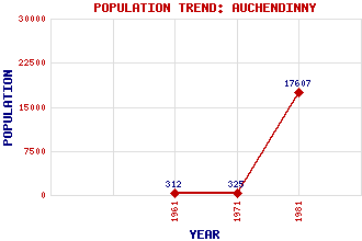
Auchendinny Classification and Statistics Settlement Type: village Population (1981): 17607 (Combined with Penicuik) (1971): 325 (1961): 312 Tourist Rating: No Text of Entry Updated: 16-MAR-2012 Location Latitude: 55.8454°N Longitude: 3.1929°W National Grid Reference: NT 254 620 A range of modern and historical maps are accessible through the map tab on the right of this page Get directions by entering the UK postcode of your location, home or hotel here eg. EH1 3YT References and Further Reading Thomas, Jane (1995) Midlothian: An Illustrated Architectural Guide. The Rutland Press, Edinburgh Use the tabs on the right of this page to see other parts of this entry Related Entries There are 18 related entries. (2 Attractions, 1 Council Area, 1 Historical County, 7 Features, 1 Parish, 2 People and 4 Settlements) Names that are not linked do not currently contain any information. Attractions: Sophia Inglis Memorial Woodhouselee Castle Council Area: Midlothian Features: Auchendinny House Craiglockhart Glencorse Burn Glencorse Reservoir North Esk, River Redhall House Rosslynlee Hospital Historical Counties: Midlothian Parishes: Glencorse People: Sir William Bruce Archibald Fletcher Settlements: Howgate Kirkhill Peebles Penicuik
There are 18 related entries. (2 Attractions, 1 Council Area, 1 Historical County, 7 Features, 1 Parish, 2 People and 4 Settlements)
Names that are not linked do not currently contain any information.
By using our site you agree to accept cookies, which help us serve you better