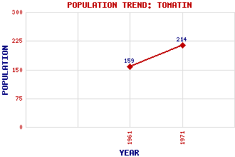
Tomatin Classification and Statistics Settlement Type: village Population (1971): 214 (1961): 159 Tourist Rating: Yes Text of Entry Updated: 18-JAN-2007 Location Latitude: 57.3339°N Longitude: 3.99°W National Grid Reference: NH 803 288 A range of modern and historical maps are accessible through the map tab on the right of this page Get directions by entering the UK postcode of your location, home or hotel here eg. EH1 3YT Use the tabs on the right of this page to see other parts of this entry Related Entries There are 31 related entries. (1 Attraction, 1 Council Area, 1 Historical County, 16 Features, 1 Parish, 1 Person and 10 Settlements) Names that are not linked do not currently contain any information. Attractions: Tomatin Distillery Council Area: Highland Features: A9 Trunk Road Beinn Bhreac Mhor Braigh Bhruthaich, Loch Carn Dearg Dearn, Strath Farr Wind Farm Findhorn Viaduct Findhorn Viaduct Findhorn, River Glenmazeran Forest Highland Line Mazeran, Glen Monadhliath Mountains Slochd Summit Stuirteag, Loch nan Tomatin House Historical Counties: Inverness-shire Parishes: Moy and Dalarossie People: Thomas Telford Settlements: Balvraid Clune Coignafearn Corrybrough Invereen Inverness Raigbeg Ruthven Slochd Woodend
There are 31 related entries. (1 Attraction, 1 Council Area, 1 Historical County, 16 Features, 1 Parish, 1 Person and 10 Settlements)
Names that are not linked do not currently contain any information.
By using our site you agree to accept cookies, which help us serve you better