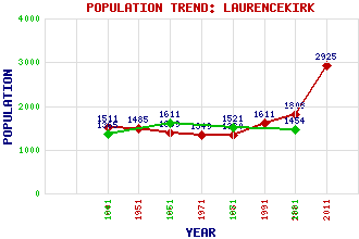
Laurencekirk Classification and Statistics Settlement Type: village Population (2011): 2925 (2001): 1808 (1991): 1611 (1981): 1330 (1971): 1349 (1961): 1389 (1951): 1485 (1901): 1511(Police Burgh) (1881): 1454 (1871): 1521 (1851): 1611 (1841): 1365 Tourist Rating: No Text of Entry Updated: 06-JAN-2014 Location Latitude: 56.835°N Longitude: 2.4637°W National Grid Reference: NO 718 716 A range of modern and historical maps are accessible through the map tab on the right of this page Get directions by entering the UK postcode of your location, home or hotel here eg. EH1 3YT GeographyLaurencekirk lies along a ridge within a rich agricultural plain that is separated from the coastal plain by the Hills of Garvock. Use the tabs on the right of this page to see other parts of this entry Related Entries There are 39 related entries. (0 Attractions, 1 Council Area, 1 Historical County, 14 Features, 1 Parish, 6 People and 16 Settlements) Names that are not linked do not currently contain any information. Council Area: Aberdeenshire Features: Cairn o' Mount Drumtochty Castle East Coast Main Line Garvock, Hill of Howe of the Mearns Laurencekirk Railway Station Luther Water Mearns Academy Philla Cairn Smart's Cairn St James's Lochs Strathmore, Valley of Thornton Castle Tullo Wind Farm Historical Counties: Kincardineshire Parishes: Laurencekirk People: James Beattie Francis Garden(Lord Gardenstone) Lewis Grassic Gibbon(James Leslie Mitchell) Dr. Samuel Johnson Alexander Ross George Wishart Settlements: Aberdeen Arbuthnott Auchenblae Brechin Drumlithie Fettercairn Fordoun Garvock Gourdon Inverbervie Johnshaven Marykirk Montrose North Water Bridge St Cyrus Stonehaven
There are 39 related entries. (0 Attractions, 1 Council Area, 1 Historical County, 14 Features, 1 Parish, 6 People and 16 Settlements)
Names that are not linked do not currently contain any information.
By using our site you agree to accept cookies, which help us serve you better