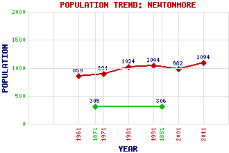
Newtonmore Classification and Statistics Settlement Type: village Population (2011): 1094 (2001): 982 (1991): 1044 (1981): 1024 (1971): 894 (1961): 859 (1881): 306 (1871): 305 Tourist Rating: No Text of Entry Updated: 06-DEC-2020 Location Latitude: 57.064°N Longitude: 4.1223°W National Grid Reference: NN 714 990 A range of modern and historical maps are accessible through the map tab on the right of this page Get directions by entering the UK postcode of your location, home or hotel here eg. EH1 3YT Use the tabs on the right of this page to see other parts of this entry Related Entries There are 46 related entries. (4 Attractions, 1 Council Area, 1 Historical County, 1 Event, 19 Features, 1 Parish, 6 People and 13 Settlements) Names that are not linked do not currently contain any information. Attractions: Cairngorms National Park, The Clan Macpherson Museum Highland Folk Museum, The Wildcat Experience Council Area: Highland Events: Highland Clearances, The Features: A9 Trunk Road Badenoch Badenoch and Strathspey Calder, River Carn Ballach Carn Ban Carn Dearg Corrieyairack Pass Cuaich Power Station Dalwhinnie Railway Station Lochaber Hydro-Electric Power Scheme Mashie, River Newtonmore Golf Club Newtonmore Railway Station Ordan Shios Ralia Lodge Spey Dam and Reservoir Spey, Loch Spey, River Historical Counties: Inverness-shire Parishes: Kingussie and Insh People: Dr. John Cattanach George 'Phil' Macpherson(G.P.S. Macpherson) Cameron McNeish Joseph Mitchell David Smith General George Wade Settlements: Aberarder Balgowan Blargie Fort William Inverness Kingussie Kinloch Laggan Laggan Perth Phones Pitlochry Ralia Ruthven
There are 46 related entries. (4 Attractions, 1 Council Area, 1 Historical County, 1 Event, 19 Features, 1 Parish, 6 People and 13 Settlements)
Names that are not linked do not currently contain any information.
By using our site you agree to accept cookies, which help us serve you better