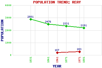
Reay Classification and Statistics Settlement Type: village Population (1971): 283 (1961): 187 (1881): 2191 (1871): 2331 (1861): 2476 (1831): 2881 Tourist Rating: N/A Text of Entry Updated: 01-JUN-2010 Location Latitude: 58.5569°N Longitude: 3.7908°W National Grid Reference: NC 959 646 A range of modern and historical maps are accessible through the map tab on the right of this page Get directions by entering the UK postcode of your location, home or hotel here eg. EH1 3YT Use the tabs on the right of this page to see other parts of this entry Related Entries There are 18 related entries. (1 Attraction, 1 Council Area, 1 Historical County, 1 Family, 11 Features, 1 Parish, 1 Person and 1 Settlement) Names that are not linked do not currently contain any information. Attractions: Dounreay Council Area: Highland Families: MacKay Features: Akran, Loch Caithness Forsinard Railway Station Moine, Loch na Reay Burn Reay Golf Club Sandside Bay Sandside Burn Sandside Head Seilge, Loch na Sletill, Loch Historical Counties: Caithness Parishes: Reay People: Elizabeth Leveson-Gower(Countess of Sutherland) Settlements: Thurso
There are 18 related entries. (1 Attraction, 1 Council Area, 1 Historical County, 1 Family, 11 Features, 1 Parish, 1 Person and 1 Settlement)
Names that are not linked do not currently contain any information.
By using our site you agree to accept cookies, which help us serve you better