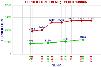
Clackmannan Classification and Statistics Settlement Type: village Population (2011): 3442 (2001): 3450 (1991): 3420 (1981): 3258 (1971): 3248 (1961): 2476 (1951): 2356 (1881): 1503 (1871): 1309 (1861): 1159 (1841): 1077 Tourist Rating: Text of Entry Updated: 11-DEC-2020 Location Latitude: 56.1074°N Longitude: 3.7493°W National Grid Reference: NS 913 919 A range of modern and historical maps are accessible through the map tab on the right of this page Get directions by entering the UK postcode of your location, home or hotel here eg. EH1 3YT Use the tabs on the right of this page to see other parts of this entry Related Entries There are 25 related entries. (3 Attractions, 1 Council Area, 1 Historical County, 1 Family, 4 Features, 1 Parish, 9 People and 5 Settlements) Names that are not linked do not currently contain any information. Attractions: Alloa Tower Gartmorn Dam Country Park Mannan, Stone of Council Area: Clackmannanshire Families: Bruce Features: Castlebridge Business Park Clackmannan Pow Clackmannan Tower Forth, River Historical Counties: Clackmannanshire Parishes: Clackmannan People: Robert Burns William Burns James Gillespie Graham Rev. John Jamieson King Malcolm IV(Malcolm the Maiden) Sadie McLellan King Robert I(Robert the Bruce) Saint Serf(St. Serf) James Shearer Settlements: Alloa Bath Inch of Ferryton Kincardine Lookaboutye
There are 25 related entries. (3 Attractions, 1 Council Area, 1 Historical County, 1 Family, 4 Features, 1 Parish, 9 People and 5 Settlements)
Names that are not linked do not currently contain any information.
By using our site you agree to accept cookies, which help us serve you better