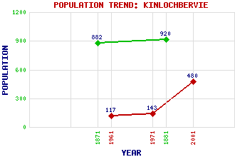
Kinlochbervie (KLB) Classification and Statistics Settlement Type: village Population (2001): 480 (1971): 143 (1961): 117 (1881): 920 (1871): 882 Tourist Rating: N/A Text of Entry Updated: 03-OCT-2010 Location Latitude: 58.4586°N Longitude: 5.0493°W National Grid Reference: NC 222 563 A range of modern and historical maps are accessible through the map tab on the right of this page Get directions by entering the UK postcode of your location, home or hotel here eg. EH1 3YT Use the tabs on the right of this page to see other parts of this entry Related Entries There are 35 related entries. (1 Attraction, 1 Council Area, 1 Historical County, 16 Features, 1 Parish, 2 People and 13 Settlements) Names that are not linked do not currently contain any information. Attractions: Polin Bay Council Area: Highland Features: An Grianan Bervie, Loch Chonnaidh, Eilean a' Clash, Loch Dubh Sgeirean Dubh, Eilean Dughaill, Loch Gainimh, Loch na Glas Leac Inchard, Loch Innis na Ba Buidhe, Loch Kinlochbervie High School Larach, Loch na Na Cluasnadh Roin Mor, Eilean an Sutherland Historical Counties: Sutherland Parishes: Eddrachillis People: Robert Gordon McBeath Thomas Telford Settlements: Badcall Balchrick Blairmore Droman Durness Golspie Laxford Bridge Lochinver Oldshore Beg Oldshoremore Polin Rhiconich Sheigra
There are 35 related entries. (1 Attraction, 1 Council Area, 1 Historical County, 16 Features, 1 Parish, 2 People and 13 Settlements)
Names that are not linked do not currently contain any information.
By using our site you agree to accept cookies, which help us serve you better