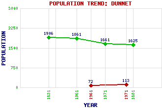
Dunnet Classification and Statistics Settlement Type: locality Population (1971): 113 (1961): 72 (1881): 1625 (1871): 1661 (1861): 1861 (1831): 1906 Tourist Rating: N/A Text of Entry Updated: 18-SEP-2003 Location Latitude: 58.6225°N Longitude: 3.3464°W National Grid Reference: ND 219 713 A range of modern and historical maps are accessible through the map tab on the right of this page Get directions by entering the UK postcode of your location, home or hotel here eg. EH1 3YT Use the tabs on the right of this page to see other parts of this entry Related Entries There are 21 related entries. (1 Attraction, 1 Council Area, 1 Historical County, 10 Features, 1 Parish, 2 People and 5 Settlements) Names that are not linked do not currently contain any information. Attractions: Westside Croft Council Area: Highland Features: Black Loch Briga Head Bushta, Loch of Caithness Courtfall Loch Dunnet Bay Dunnet Head Muirs, Loch of Ness, Point of St John's Loch Historical Counties: Caithness Parishes: Dunnet People: Richard Oswald Timothy Pont Settlements: Corsback John o' Groats Lochend Thurso West Dunnet
There are 21 related entries. (1 Attraction, 1 Council Area, 1 Historical County, 10 Features, 1 Parish, 2 People and 5 Settlements)
Names that are not linked do not currently contain any information.
By using our site you agree to accept cookies, which help us serve you better