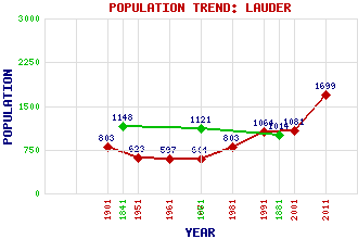
Lauder Classification and Statistics Settlement Type: village Population (2011): 1699 (2001): 1081 (1991): 1064 (1981): 803 (1971): 604 (1961): 597 (1951): 623 (1901): 803(Royal and Municipal Burgh) (1881): 1014 (1861): 1121 (1841): 1148 Tourist Rating: Text of Entry Updated: 13-JUN-2016 Location Latitude: 55.7195°N Longitude: 2.7513°W National Grid Reference: NT 529 476 A range of modern and historical maps are accessible through the map tab on the right of this page Get directions by entering the UK postcode of your location, home or hotel here eg. EH1 3YT Use the tabs on the right of this page to see other parts of this entry Related Entries There are 50 related entries. (3 Attractions, 1 Council Area, 1 Historical County, 1 Family, 17 Features, 1 Parish, 6 People and 20 Settlements) Names that are not linked do not currently contain any information. Attractions: Sir Walter Scott Way Southern Upland Way Thirlestane Castle Council Area: Scottish Borders Families: Lauder Features: Boon Hill Boondreigh Burn Boondreigh Water Collie Law Crib Law Dun Law Wind Farm Eden Water Fallago Rig Wind Farm Herring Road Lauder Burn Lauder Golf Club Leader Water Macedonia Scoured Rig Staunchley Hill Torquhan Twin Law Historical Counties: Berwickshire Parishes: Lauder People: Sir William Bruce Thomas Dickson Archibald Douglas(5th Earl of Angus, Bell-the-Cat) Rev. James Guthrie King James III Rev. John Wilson Settlements: Blainslie Blythe Boon Bruntaburn Carfraemill Cathpair Edinburgh Fountainhall Houndslow Killochyett Langshaw Legerwood Nether Blainslie Oxton Spottiswoode Stow Thirlestane Thornydykes Threepwood Westruther
There are 50 related entries. (3 Attractions, 1 Council Area, 1 Historical County, 1 Family, 17 Features, 1 Parish, 6 People and 20 Settlements)
Names that are not linked do not currently contain any information.
By using our site you agree to accept cookies, which help us serve you better