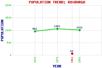
Roxburgh Classification and Statistics Settlement Type: village Population (1961): 61 (1881): 1012 (1871): 1053 (1831): 962 Tourist Rating: Text of Entry Updated: 03-DEC-2010 Location Latitude: 55.5681°N Longitude: 2.4804°W National Grid Reference: NT 698 306 A range of modern and historical maps are accessible through the map tab on the right of this page Get directions by entering the UK postcode of your location, home or hotel here eg. EH1 3YT Use the tabs on the right of this page to see other parts of this entry Related Entries There are 24 related entries. (2 Attractions, 1 Council Area, 1 Historical County, 2 Families, 6 Features, 1 Parish, 5 People and 6 Settlements) Names that are not linked do not currently contain any information. Attractions: Kalemouth Suspension Bridge Roxburgh Castle Council Area: Scottish Borders Families: Cockburn Kerr Features: Clearburn Loch Crooked Loch Macedonia Roxburghe Hotel Teviot, River Wallace's Tower Historical Counties: Roxburghshire Parishes: Roxburgh People: King Alexander III Sir Thomas Lauder Brunton King James II Sir Alexander Ramsay of Dalhousie Sir David Steel(Lord Steel of Aikwood) Settlements: Kelso Kirkbank Manorhill Nisbet Rutherford Smailholm
There are 24 related entries. (2 Attractions, 1 Council Area, 1 Historical County, 2 Families, 6 Features, 1 Parish, 5 People and 6 Settlements)
Names that are not linked do not currently contain any information.
By using our site you agree to accept cookies, which help us serve you better