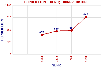
Bonar Bridge Classification and Statistics Settlement Type: village Population (1991): 840 (1981): 533 (1971): 519 (1961): 437 Tourist Rating: N/A Text of Entry Updated: 19-SEP-2003 Location Latitude: 57.8921°N Longitude: 4.3464°W National Grid Reference: NH 610 916 A range of modern and historical maps are accessible through the map tab on the right of this page Get directions by entering the UK postcode of your location, home or hotel here eg. EH1 3YT Use the tabs on the right of this page to see other parts of this entry Related Entries There are 47 related entries. (0 Attractions, 1 Council Area, 1 Historical County, 30 Features, 1 Parish, 3 People and 11 Settlements) Names that are not linked do not currently contain any information. Council Area: Highland Features: Aberdeen-Inverness Line Alladale, Glen Amat Amat Forest Ardgay Railway Station Beag, Gleann Beinn Tharsuinn Bonar Bridge-Ardgay Golf Club Braelangwell Lodge Buidhe, Loch Carn Bhrain Carron, River Chuinneag, Loch Crom Loch Diebidale, Glen Dornoch Firth Dun Criech Easter Ross Evelix, River Invershin Railway Station Kyle of Sutherland Lagain, Loch an Laro, Loch Migdale, Loch Oykel, River Shin, River Strathcarron Struie Wester Fearn Burn Wester Fearn Point Historical Counties: Sutherland Parishes: Creich People: Sir William Arrol George Rainy Thomas Telford Settlements: Achnahanat Ardchronie Ardgay Aultnamain Inn Balblair Culrain Dounie Kincardine Linsidemore Little Creich Migdale
There are 47 related entries. (0 Attractions, 1 Council Area, 1 Historical County, 30 Features, 1 Parish, 3 People and 11 Settlements)
Names that are not linked do not currently contain any information.
By using our site you agree to accept cookies, which help us serve you better