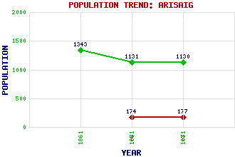
Arisaig (Arasaig) Classification and Statistics Settlement Type: village Population (1971): 177 (1961): 174 (1881): 1130 (1871): 1131 (1861): 1343 Tourist Rating: Yes Text of Entry Updated: 30-APR-2020 Location Latitude: 56.9115°N Longitude: 5.8439°W National Grid Reference: NM 661 866 A range of modern and historical maps are accessible through the map tab on the right of this page Get directions by entering the UK postcode of your location, home or hotel here eg. EH1 3YT Use the tabs on the right of this page to see other parts of this entry Related Entries There are 34 related entries. (4 Attractions, 1 Council Area, 1 Historical County, 19 Features, 1 Parish, 0 People and 8 Settlements) Names that are not linked do not currently contain any information. Attractions: Land, Sea and Islands Centre, The Road to the Isles, The Skye West Highland Line Council Area: Highland Features: Arisaig Arisaig House Arisaig Railway Station Ban, Eilean Beinn nan Cabar Carn a' Mhadaidh-ruaidh Ceall, Loch nan Gobhar, Eilean nan Ighe, Eilean Lochaber Lochailort Railway Station Luinga Bheag Luinga Mhor Sgeir Ghainmheach Sgeir an Fheoir Sidhean Mor Small Isles Traigh Golf Club Uamh, Loch nan Historical Counties: Inverness-shire Parishes: Arisaig and Moidart Settlements: Back of Keppoch Bunacaimb Fort William Gortenachullish Keppoch Kinloid Mallaig Portnaluchaig
There are 34 related entries. (4 Attractions, 1 Council Area, 1 Historical County, 19 Features, 1 Parish, 0 People and 8 Settlements)
Names that are not linked do not currently contain any information.
By using our site you agree to accept cookies, which help us serve you better