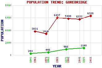
Gorebridge Classification and Statistics Settlement Type: small town Population (2011): 6328 (2001): 5777 (1991): 5888 (1981): 6037 (1971): 3426 (1961): 3831 (1881): 1148 (1871): 966 (1861): 446 (1841): 240 Tourist Rating: No Text of Entry Updated: 22-JUL-2019 Location Latitude: 55.8414°N Longitude: 3.0477°W National Grid Reference: NT 344 614 A range of modern and historical maps are accessible through the map tab on the right of this page Get directions by entering the UK postcode of your location, home or hotel here eg. EH1 3YT Use the tabs on the right of this page to see other parts of this entry Related Entries There are 39 related entries. (5 Attractions, 1 Council Area, 1 Historical County, 14 Features, 1 Parish, 2 People and 15 Settlements) Names that are not linked do not currently contain any information. Attractions: Arniston House Borders Railway Gore Glen Woodland Park Loquhariot Doocot Vogrie Country Park Council Area: Midlothian Features: A7 Trunk Road Arniston Birkenside Borthwick Castle Broad Law Edgelaw Reservoir Gala Water Gore Water Gorebridge Railway Station Harvieston House Newbyres Castle Rosebery Reservoir Torfichen Hill Wright's Houses Stane Historical Counties: Midlothian Parishes: Newbattle People: Annette Crosbie Annie Shepherd Swan Settlements: Arniston Engine Borthwick Carrington Catcune Crichton Fushiebridge Gowkshill Loanhead Middleton Newlandrig North Middleton Southside Soutra Temple Tynehead
There are 39 related entries. (5 Attractions, 1 Council Area, 1 Historical County, 14 Features, 1 Parish, 2 People and 15 Settlements)
Names that are not linked do not currently contain any information.
By using our site you agree to accept cookies, which help us serve you better