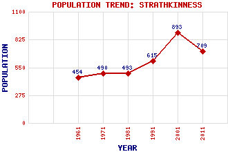
Strathkinness Classification and Statistics Settlement Type: village Population (2011): 709 (2001): 893 (1991): 615 (1981): 493 (1971): 490 (1961): 454 Tourist Rating: No Text of Entry Updated: 17-FEB-2008 Location Latitude: 56.335°N Longitude: 2.8749°W National Grid Reference: NO 460 162 A range of modern and historical maps are accessible through the map tab on the right of this page Get directions by entering the UK postcode of your location, home or hotel here eg. EH1 3YT Use the tabs on the right of this page to see other parts of this entry Related Entries There are 12 related entries. (1 Attraction, 1 Council Area, 1 Historical County, 5 Features, 1 Parish, 1 Person and 2 Settlements) Names that are not linked do not currently contain any information. Attractions: St Andrews Cathedral Council Area: Fife Features: Clatto Hill Duke's Golf Course Kinness Burn Magus Muir Swilken Burn Historical Counties: Fife Parishes: St Andrews and St Leonards People: Archbishop James Sharp Settlements: Magus St Andrews
There are 12 related entries. (1 Attraction, 1 Council Area, 1 Historical County, 5 Features, 1 Parish, 1 Person and 2 Settlements)
Names that are not linked do not currently contain any information.
By using our site you agree to accept cookies, which help us serve you better