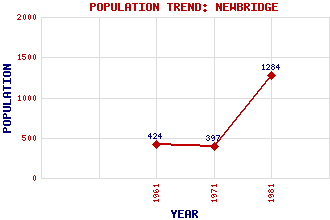
Newbridge Classification and Statistics Settlement Type: village Population (1981): 1284 (Combined with Ratho Station) (1971): 397 (1961): 424 Tourist Rating: N/A Text of Entry Updated: 19-SEP-2003 Location Latitude: 55.9401°N Longitude: 3.4104°W National Grid Reference: NT 120 728 A range of modern and historical maps are accessible through the map tab on the right of this page Get directions by entering the UK postcode of your location, home or hotel here eg. EH1 3YT Use the tabs on the right of this page to see other parts of this entry Related Entries There are 16 related entries. (2 Attractions, 1 Council Area, 1 Historical County, 10 Features, 1 Parish, 1 Person and 0 Settlements) Names that are not linked do not currently contain any information. Attractions: Almond Valley Viaduct Forth Road Bridge Council Area: City of Edinburgh Features: Almond Valley Almond, River Clifton Hall Edinburgh-Dunblane Line Gogarburn Golf Club Hallyards Castle Hillwood Quarry Huly Hill Newliston Ratho Park Golf Club Historical Counties: West Lothian Parishes: Kirkliston People: Andrew (Andy) Mooney
There are 16 related entries. (2 Attractions, 1 Council Area, 1 Historical County, 10 Features, 1 Parish, 1 Person and 0 Settlements)
Names that are not linked do not currently contain any information.
By using our site you agree to accept cookies, which help us serve you better