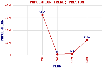
Preston Classification and Statistics Settlement Type: hamlet Population (1981): 1206 (Combined with East Linton) (1971): 104 (1961): 68 (1951): 3233 Tourist Rating: N/A Text of Entry Updated: 22-JUN-2006 Location Latitude: 55.9932°N Longitude: 2.654°W National Grid Reference: NT 593 780 A range of modern and historical maps are accessible through the map tab on the right of this page Get directions by entering the UK postcode of your location, home or hotel here eg. EH1 3YT Use the tabs on the right of this page to see other parts of this entry Related Entries There are 14 related entries. (4 Attractions, 1 Council Area, 1 Historical County, 1 Family, 1 Feature, 1 Parish, 3 People and 2 Settlements) Names that are not linked do not currently contain any information. Attractions: Phantassie Doocot Preston Mill Prestonkirk Parish Church St Baldred's Well Council Area: East Lothian Families: Preston Features: Tyne, River Historical Counties: East Lothian Parishes: Prestonkirk People: Sir William Hamilton John Rennie Patrick Shirreff Settlements: East Linton Tyninghame
There are 14 related entries. (4 Attractions, 1 Council Area, 1 Historical County, 1 Family, 1 Feature, 1 Parish, 3 People and 2 Settlements)
Names that are not linked do not currently contain any information.
By using our site you agree to accept cookies, which help us serve you better